Silver Mines & Native Americans
There’s no clear record of the original inspiration for the name Mahockney, so we must piece the puzzle together. The earliest recorded use is in a 1721 deed of sale recorded by the son-in-law of the plantation house’s builder Robert Tomlin, but that 1721 deed states it was already “Six hundred acres commonly known by the name of the Mahockney.” The earliest part of the house (cellar, chimneys, first floor) certainly dated back more than 40 years at that point, first drawn on a 1680 map.
So who named the plantation at the beginning, and why?


Detail, John Smith’s 1612 Map of Virginia
Recent historical research has uncovered the likely origins in a fascinating explorer’s tale, linking the house to the somewhat-distant but still-in-Virginia Mahock Indian tribe, also known as the Manahock or Manahoac and first encountered and recorded north of Fredericksburg by Capt. John Smith in 1608. The Mahocks, a small Siouan Native American tribe in central Virginia, are chiefly known in history for Smith’s encounter – and the tribe’s fear that he and his English had come to “take their world from them.” (Not a bad guess on their part.) The Mahock moved further west and south and disappeared from history by 1728. Due to their obscurity, recent generations haven’t make the connection.
A fresh look at the record, however, points to another encounter with the Mahock, on a little-known 1670 frontier expedition – with eventual Mahockney owner Robert Tomlin probably along as one of the explorers, just months before buying his new homestead land in 1671.
Here’s the tale of the expedition: In the decade before Bacon’s Rebellion of 1676, the colony’s Governor Sir William Berkeley actively pushed the frontiers, and eagerly did business with far-flung Indian tribes along the upper reaches of the James, York and Rappahannock rivers. Much as Thomas Jefferson would do nearly 150 years later with Lewis & Clark, in 1669 Gov. Berkeley commissioned an ambitious expedition to be led by recent immigrant and famed European explorer John Lederer, hoping to discover the “western passage” and possibly even find the fabled Spanish mines of silver and copper.
In March 1669 Lederer executed a first trip west accompanied by three Indian guides, crossing the York and Rappahannock and reaching the lower Appalachian range. Circling back within a month, he began to organize a much larger troop for a longer trek. For the second Lederer Expedition he had “twenty Christian Horse[men] and five Indians on foot.” In his own journal Lederer titled that excursion as “From the Falls of Powhatan, alias James-River, in Virginia, to Mahock in the Apalataean Mountains,” labeling his path as “The March to Mahock.”
Lederer’s own map, published with his account in 1672 (click to enlarge):

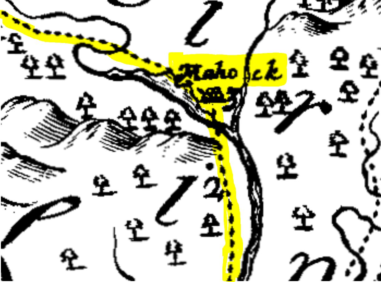
The party wound up passing through several tribal villages including Mahock and spent time with the Native Americans. Although most of his party actually broke off just past Mahock and returned to Jamestown early, in fear of that tribe’s violent reputation, this second journey lit a fire of excitement for Lederer. After returning he wrote: “Some pieces of Silver unwrought I purchased myself [from Indians encountered along the way], for no other end then to justify this account I give  of my Second Expedition,” and he predicted greater success “were I accompanied with half a score resolute youths that would have stuck to me in a further discovery towards the Spanish Mines.”
Eager to seize upon the tantalizing evidence of riches among the Indians, Lederer quickly began organizing an ambitious third voyage westward for August 1670. One can imagine how he used the stories of his tantalizing earlier encounters, of seeing silver, pearl, and copper among the Indians, and the stirring impact on those who heard about the treasure hunt. His passion was supported by a written report circulated by one of the Virginians along on the second trek; Thomas Ludwell wrote that if a third expedition could be tried, “there we do suppose will be the end of our labour in some happy discovery which we shall attempt in the end of summer with provisions to passe the river as allso to try for mines, being yet very confident that the bowells of those barren hills are not without silver or gold.”
As Lederer gathered recruits, Robert Tomlin was already in the area, having carved out 350 acres of nearby wilderness 15 years before for an early home on Occupacia Creek that no longer survives, as one of only two dozen or so English settlers then living within thirty miles on that stretch of the south side of the Rappahannock River. We know that Lederer recruited his third group of “nine English Horse[men], and five Indians on foot” from settlements in the area, and the group’s embarkation point was near Port Royal at the frontier home of Robert Taliaferro. Taliaferro’s father-in-law Col. John Catlett, a well-known navigator and cartographer, is the only other recruit listed in Lederer’s account. Records show that Robert Tomlin knew both the Taliaferro family and navigator Catlett, who had himself mapped land for Tomlin in 1666.
 With Tomlin probably along as one of the unnamed “English horse” on that third expedition, Lederer and crew embarked, heading west for Mahock in a quest for treasure. But this journey was a hard one (you can read Lederer’s own full account here); they veered off track and missed Mahock, and found no treasure. The party became the first Europeans to climb the Blue Ridge Mountains and to see the Shenandoah Valley, but “the ascent was so steep, the cold so intense, and we so tired,” Lederer wrote afterwards, they dejectedly turned for home, in what must have been a poignant return. Lederer made no more attempts.
Within several months Robert Tomlin purchased the land for his new plantation home, on March 21, 1671 – the land which within a few years would “commonly be known by the name of The Mahockney.” According to linguists, “-ney” was a common Anglo-Saxon suffix typically meaning a placename or “island,” attached to a nearby tribal or personal name.
We can imagine that the quest for Mahock had been the experience of a lifetime for those pioneers, and might assume that Tomlin coined the new name as a romantic reminder, of a village and tribe that would soon disappear from the map but would remain in tribute to the bold pursuit of frontier riches in the new America.

