
This site is a collection of historical items related to Mahockney, a historic house and farm located on Mount Landing Creek in Essex County, in Virginia’s Tidewater region. The links on the menu sidebar lead to chronologically-arranged stories, records, photographs, and other materials from Mahockney’s 350+ years.

One of the historic homes of Virginia –
still standing, still in private hands
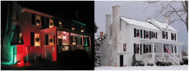
The classic early colonial home at Mahockney, patented as a plantation in 1663, stands at the center of 1,200 acres of farmland in Upper Mount Landing, Virginia, on Mount Landing Creek just three miles above the spot where it feeds into the Rappahannock River. That’s also the very spot where Capt. John Smith encountered the Rappahannock Indians on his initial 1608 exploration upriver from Jamestown. Today Mahockney remains a private home, restored and preserved as a remarkable tribute to more than three and a half centuries of American history.
The current structure consists of three sections: the brick-foundation frame southern portion of the house (on the left in photo), where at least the chimneys, basement, and foundation may predate Bacon’s Rebellion of 1676 with battles nearby; on the north end a substantial brick two-story and high-ceilinged cellar (on the right) dating to 1820; and third, a substantial addition behind, dating from the early part of the 20th Century.
 Mahockney in 1898
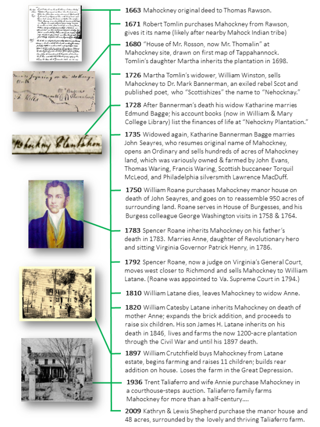

Mahockney house bottom left, the farm and forest around it, Rappahannock River at top
-
- 1663 The Original Patent

-

- Earliest Map of Mahockney

-
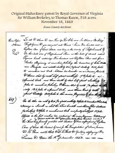
- First use of “Mahockney”

-
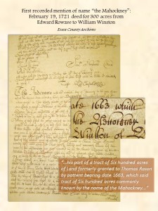
- Mark Bannerman, Rebel Poet from Scotland

-
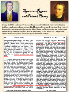
- Patrick Henry

-
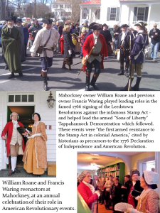
- American Revolution

-

- William Roane, Patriot

-
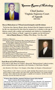
- Chief Justice Spencer Roane

-
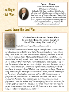
- Civil War


Why the Indian name “Mahockney”? The answer is a romantic treasure-hunt story of silver mines… Click here to learn more


Click photo left to see recent archaeological finds from the grounds
For more on the architectural history and evidence click here.
Click here for more about the people who’ve lived at Mahockney.


Such an interesting read, what a privilege to live in such a place Kathy…and I know it couldn’t be in better hands. You are to be congratulated!
LikeLike
Thank you Karen! Very gracious of you. Come visit sometime 🙂
LikeLike
Lewis, you’ve done such a beautiful job on the site, as well as the research.
Miles
LikeLike
Miles, that is certainly high praise, especially from you, thank you my friend. I hope all is well in your world, and that you’ll come visit the real (non-virtual) site sometime!
LikeLike
I’m a black american and wonder if this is the family who owned by ancestors. I my brother, father, and grandfather have the name Robert Tomlin . My grandfather got married in Fayette, Georgia in 1849.
LikeLiked by 1 person
Hi Ms. Merriweather – Thanks for the comment last month (and apologies for not seeing it until just now). Good question! I wish I had more old records of the African-Americans who lived here… There’s certainly a chance, as the Tomlins owned Mahockney (with many slaves) for about half-a-century. I’ve just posted some more information at this page which you might find helpful: https://mahockney.org/who-lived-here/.
Very best regards and Happy Thanksgiving! -lewis shepherd
LikeLike
In case you don’t know, you may be interested to learn that Judge David Johnson has just published a biography of Judge Spencer Roane with LSU Press. It’s a fine account.
LikeLike
Thanks for the comment, Prof. Gutzman. We have indeed read the book here at Mahockney, indeed a fine account though tragically short on his childhood and maturing here at the manor house 🙂 We had an early tip-off that Judge Johnson was writing it, from none other than the current Chief Justice of Virginia, who gave us a tour of his chambers in exchange for Roane stories 🙂
LikeLike
Hello – I am researching my sons ancestry as a Christmas gift. Their father passed away in 1995 and they have very little knowledge of the father’s family history. In my research, I found one ancestor who died at Mahockney Plantation – Edward Gouldman, 1st husband of Martha Tomlin, daughter of Robert Tomlin, second owner of the plantation. It was sad to see that Martha Tomlin Gouldman’s 2nd husband, William Winston, sold the plantation after her death. I never expected to find that the plantation still exists and pictures of such a beautiful place. An amazing find to add a little extra to their family history. Thank you.
LikeLike
I love this Kathryn. You’re a blessing!!!
LikeLike
Lewis, you’re research is so thorough and aligns with my findings of my Roane ancestors. Great work. I can’t wait to visit!!!
LikeLike